
- Distance: 15.5 miles - Min/max elev.: 2205'/4882' - Elev. gain/loss: 3148'/-3148' - Pedestrian, Mt Bike Starting at Fairy Ponds TH, head out FS Rd 2060 ...
- Distance: 15.5 miles - Min/max elev.: 2205'/4882' - Elev. gain/loss: 3148'/-3148' - Pedestrian, Mt Bike Starting at Fairy Ponds TH, head out FS Rd 2060 ...
- Distance: 15.7 miles - Min/max elev.: 2213'/4882' - Elev. gain/loss: 3070'/-3070' This is a pedestrian and mountain bike route. From Fairy P ...

- Distance: 18 miles - Min/max elev.: 2212'/4915' - Elev. gain/loss: 3115'/-3115' - Pedestrian, Mt Biking Starting at Fairy Ponds TH, head out FS Rd 2060 ...
- Distance: 18.1 miles - Min/max elev.: 2209'/4915' - Elev. gain/loss: 3076'/-3076' - Pedestrian and Mt BikeStarting at Fairy Ponds TH, head out FS Rd 206 ...
- Distance: 20.5 miles - Min/max elev.: 2204'/4915' - Elev. gain/loss: 3689'/-3689' Starting at Fairy Ponds TH, head southwest out FS Rd 2060 for ~3.6 mil ...
- Distance: 23.9 miles - Min/max elev.: 2215'/5848' - Elev. gain/loss: 4270'/-4270' Starting at Witzend, head out Waterline, up Bandersnatch, turn right at Red Queen. At the t ...
– Distance: 25 miles
– Min/max elev.: 2189’/4950′
– Elev. gain/loss: 3382’/-3382′
This is the simple, road-based route around the watershed, using mostly FS-2060 and the Ashland Loop Rd, counter clockwise.…
- Distance: 26.2 miles - Min/max elev.: 1946'/4930' - Elev. gain/loss: 3861'/-3861' Download the GPX file or zoom in to see turns of this clas ...
- Distance: 30.1 miles - Min/max elev.: 2189'/7187' - Elev. gain/loss: 6039'/-6039' Starting at Witzend, head out Waterline, up Bandersnatch to Red Queen. At th ...
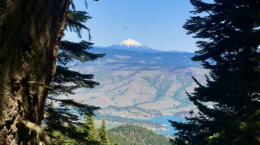
- Distance: 30 miles - Min/max elev.: 4035'/7187' - Elev. gain/loss: 4345'/-4345' This loop could be started at Four Corners, Eastview TH, BullGap, Mt Ashland, or Grouse Gap. ...
- Distance: 49.1 miles (actual miles are closer to 50) - Min/max elev.: 4052'/7489' - Elev. gain/loss: 8370'/-8370' Starting at the Mt Ashland lodge, head south ...
- Distance: 60.15 mi (actual is closer to 62) - Min/max elev.: 2931'/7469' - Elev. gain/loss: 11,564'/-11,564' Starting at the Mt Ashland lodge, head southwest through the ...